DKAN is an open-source data management platform. It treats data as content so that you can easily publish, manage, and maintain your open data no matter the size of your team or the level of technical expertise.
The Environmental Data Portal provides an easy way to find, access and reuse national data. Our main purpose is to provide easy access and safe storage for Environmental datasets to be used for monitoring, evaluating, and analysing environmental conditions and trends to support environmental planning, forecasting, and reporting requirements at all levels. We encourage you to use publicly available government data to analyse and develop tools and applications to benefit all citizens.
This Dashboard gives an overview of all the help and support documents the Inform project has created. From manuals and video instructions, to license agreement templates, interesting presentations and software (and a lot more!). You can find all links to it here.
Traditional way of life in the pacific islands in the expression of each and everybody's identity. The link between people and their natural habitat, living and unliving things is key to someone's social status, relationship to other member of its community and existence in the world. The session shall look at the importance of traditional knowledge and its relation to the environment as a way to protect existing biodiversity and thus ensuring that the cultural heritage of Pacific Island population i preserved.
Link to download a zip file containing OSM spatial files, a QGIS project, styles, license file and documentation on how to get started.
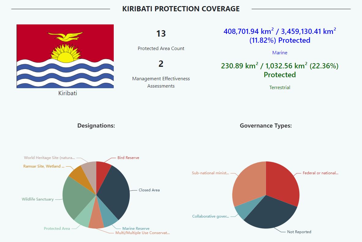
This dataset contains mapped point locations for protected areas within Kiribati. This dataset should be viewed in combination with the World Database on Protected Areas polygon locations to get a comprehensive view of all protected areas within Kiribati.
This dataset contains mapped point locations for protected areas within Kiribati. This dataset should be viewed in combination with the World Database on Protected Areas polygon locations to get a comprehensive view of all protected areas within Kiribati.
This dataset contains mapped polygon locations for protected areas within Kiribati. This dataset should be viewed in combination with the World Database on Protected Areas point locations to get a comprehensive view of all protected areas within Kiribati.
This dataset contains mapped polygon locations for protected areas within Kiribati. This dataset should be viewed in combination with the World Database on Protected Areas point locations to get a comprehensive view of all protected areas within Kiribati.
The WDPA User Manual provides information and guidance about the data held within the WDPA, including its history, how it is collected, managed and distributed, and how it should be interpreted and used for analyses and research. The Manual has been prepared for WDPA data providers and users. It is structured in 4 sections and includes 6 appendices.