This dataset holds all media resources for the State of Environment and Conservation in the Pacific Islands: 2020 Regional Report
Dataset includes various regional-scale spatial data layers in geojson format.
For the Ninth Pacific Islands Conference on Nature Conservation and Protected Areas December 2013, the Secretariat of the Pacific Regional Environment Programme (SPREP) commissioned an assessment of the status of biodiversity and conservation in Oceania.
This dataset holds all the reports that assesses the overall state of conservation in;
* Guam
* French Polynesia
* Northern Mariana Islands
* Tokelau
* Wallis and Futuna
* Pitcairn Islands
A list of international and regional multilateral environmental agreements in which each of the Pacific Island country is a party/signatory of. This is useful for SPREP activities and planning
In the 30th SPREP meeting held in September this year, the meeting supported the scaling up of environment data management in the Pacific and directed the Secretariat to initiate a process for developing a full-sized project proposal to support the scaling up environmental data management work in the region.
Later in October, the Inform Project participating countries collectively agree on the need to scale up and extend the Inform Project services beyond 2022.
For the Ninth Pacific Islands Conference on Nature Conservation and Protected Areas December 2013, Secretariat of the Pacific Regional Environment Programme (SPREP) commissioned an assessment of the status of biodiversity and conservation in Oceania. This report assesses the overall state of conservation in Kiribati using 16 indicators.
*this report wasn't published but was sent to country for checking (2013*) - to be used for the Regional SOE initiative 2019
The Pacific Network for Environmental Assessment (PNEA) Portal is an initiative of the Secretariat of the Pacific Regional Environment Programme (SPREP) to support government officials from Pacific Island countries and territories who work with environmental impact assessment (EIA), strategic environmental assessment (SEA) as well as Environmental and Social Safeguards (ESS).
The portal complements SPREP’s current capacity building program for EIA and SEA - including the recently launched Regional EIA Guidelines, the Coastal Tourism EIA guidelines, and SEA guidelines.
The ASTER Global Digital Elevation Model (GDEM) Version 3 (ASTGTM) provides a global digital elevation model (DEM) of land areas on Earth at a spatial resolution of 1 arc second (approximately 30 meter horizontal posting at the equator).
The development of the ASTER GDEM data products is a collaborative effort between National Aeronautics and Space Administration (NASA) and Japan’s Ministry of Economy, Trade, and Industry (METI). The ASTER GDEM data products are created by the Sensor Information Laboratory Corporation (SILC) in Tokyo.
This dataset has all icons for Multilateral Environment Agreements such as SDGs and Aichi
The objective of the participatory consultations with stakeholders in Bikenibeu West was to identify possible solutions to address root causes of waste problems threatening fresh and marine water quality.
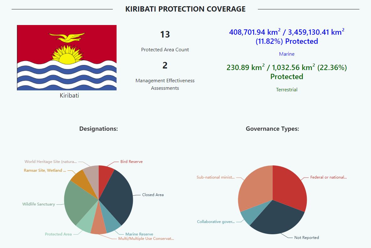
A presentation on Kiribati Protected Areas during the BIOPAMA Workshop 2018
This publication ‘Strategic Environmental Assessment – Guidelines for Pacific Island Countries and
Territories’ has been prepared to provide guidance on the application of SEA as a tool to support
environmental planning, policy and informed decision making. It provides background on the use and
benefits of SEA as well as providing tips and guiding steps on the process, including case studies, toolkits
and checklists for conducting an SEA in the Appendices.
The purpose of the PLA (Participatory Learning and Action) was mainly to exchange information at the community level and discuss issues and potential low cost solutions to address root causes of waste issues.
presentation on Kiribati's protected area
In this report, a set of recommendations is provided for each indicator to support the next best steps for management action that will advance progress towards the target outcome and support Pacific people and biodiversity.
**This pdf combines all 31 indicators in one document**